 |
||
|
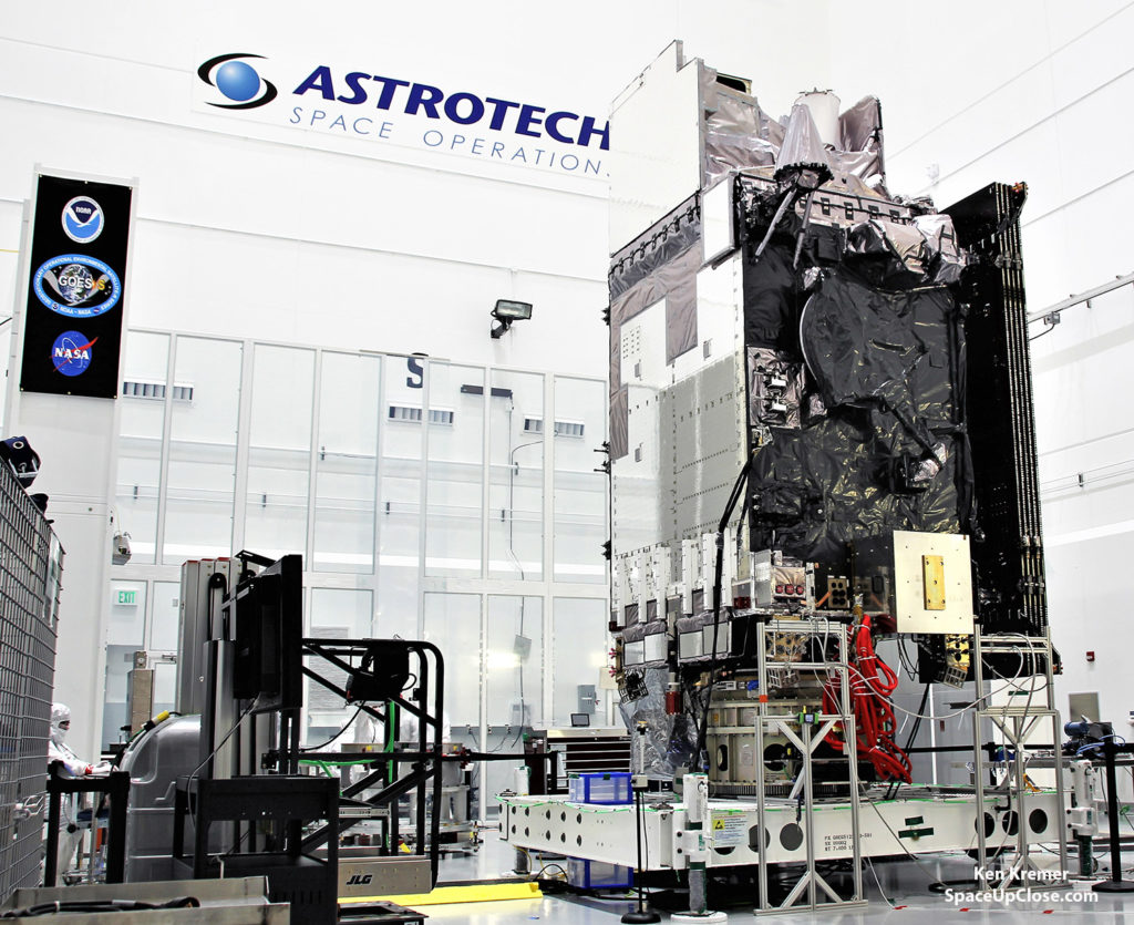
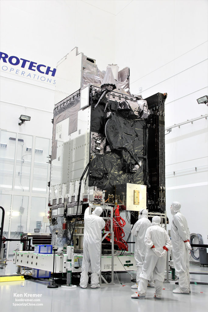
The NASA/NOAA Geostationary Operational Environmental Satellite-S (GOES-S) is being processed in the clean room at Astrotech
Space Operations, in Titusville, FL, on Jan. 16, in advance of planned launch on a ULA Atlas V slated for Mar. 1, 2018. GOES-S belongs to new constellation of America’s most advanced weather satellites. Credit: Ken Kremer/SpaceUpClose.com/kenkremer.com
KENNEDY SPACE
CENTER, FL –Liftoff of the advanced NOAA/NASA next generation GOES-S geostationary weather observation satellite this Thursday, Mar. 1 will provide vastly improved forecasts and warnings on weather, wildfires, tornadoes and cyclones for California and the western United States all the way out to Hawaii and Guam in ways that will positively impact the lives of everyday people.
Furthermore GOES-S
brings an “equivalent perspective” with vastly improved resolution that completely complements the same weather observation upgrade just accomplished for the eastern half of the US with the recently launched GOES-R observatory – now known as GOES-16/GOES East.
Once it achieves
orbit GOES-S will be renamed as GOES-17/GOES West.
“What we want is the complement of 2 imaging spacecraft on
orbit and the GOES-17 launch will do that as the second new GOES spacecraft in orbit,” FL, Tim Walsh, acting GOES-R system program director at NOAA told Space UpClose during a recent interview with reporters in the cleanroom with the spacecraft at Astrotech Space Operations in Titusville, Fl, where technicians were actively processing the probe to ready it ahead of this week’s thunderous launch.
“GOES 17 will complete the complement on orbit for NOAA.”
GOES-S is the twin
sister observatory to GOES-R, which launched late in 2016 and recently became operational – and was renamed the GOES-16/GOES East satellite for the eastern US at its geostationary orbit soaring some 22,200 mi (35800 km) above Earth.
“GOES 17 will become operation in the fall of 2018, “ Walsh
stated. “It will give us the equivalent perspective for the western US that we now have for the eastern US using the six onboard instruments namely ABI and GLM, SUVI, EXIS, SEIS and the magnetometer.”
Liftoff of the NOAA/NASA GOES-S geostationary weather
observation satellite is scheduled for March 1, 2018, near sunset at 5:02 p.m. EST aboard a United Launch Alliance (ULA) Atlas V rocket from Space Launch Complex-41 on Cape Canaveral Air Force Station in Florida.
The launch window extends for two
hours from 5:02 – 7:02 p.m. EST.
GOES-S, which stands for
Geostationary Operational Environmental Satellite–S, is a new and advanced transformational weather satellite that will vastly enhance the quality, speed and accuracy of weather forecasting available to forecasters for Earth’s Western Hemisphere after it becomes operational later this year.
GOES-S was built by prime contractor
Lockheed Martin Space Systems, Littleton, Colorado.
|
 |
|
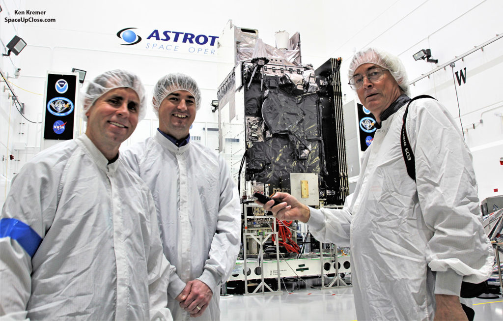
In the clean room at Astrotech
Space Operations, in Titusville, FL, Tim Walsh, acting GOES-R system program director at NOAA and Dan Lindsey, GOES-R senior scientific advisor at NOAA discuss the advanced weather observation capabilities of NASA/NOAA Geostationary Operational Environmental Satellite-S (GOES-S) with Ken Kremer/SpaceUpClose during satellite processing on Jan. 16, 2018. Launch on Atlas V set for Mar. 1, 2018. Credit: Ken Kremer/SpaceUpClose.com/kenkremer.com |
“We are seeing a revolutionary step forward in performance
with 4x better spatial resolution, 3 x as many frequencies or spectral bands,
and we receive images 5 x faster,” Walsh said already with GOES-R/GOES-16 compared
to the legacy GOES East/West satellite imager technologies “which were created
and developed in the mid-1980s.”
with 4x better spatial resolution, 3 x as many frequencies or spectral bands,
and we receive images 5 x faster,” Walsh said already with GOES-R/GOES-16 compared
to the legacy GOES East/West satellite imager technologies “which were created
and developed in the mid-1980s.”
“Currently to do a full western hemisphere image with the
current imager on orbit today takes 26 minutes. With GOES-R now we can do the
same thing in 5 minutes.”
current imager on orbit today takes 26 minutes. With GOES-R now we can do the
same thing in 5 minutes.”
“So it gives us much better severe weather forecasting and
now weather forecasting imagery.”
now weather forecasting imagery.”
“We hope to start test imaging with GOES-S by around early
May, said Walsh. “First we need to raise the temperature of the instruments
once on orbit. We will outgas them for several weeks.”
May, said Walsh. “First we need to raise the temperature of the instruments
once on orbit. We will outgas them for several weeks.”
“There is no real difference between this spacecraft GOES-S/GOES
17 and GOES-R/GOES 16.”
17 and GOES-R/GOES 16.”
But
they will be located at different positions in the equatorial belt to obtain different
views. Together they will be able to
image the entire US and regions further out beyond to the east and west to
provide coverage of the entire Western Hemisphere.
they will be located at different positions in the equatorial belt to obtain different
views. Together they will be able to
image the entire US and regions further out beyond to the east and west to
provide coverage of the entire Western Hemisphere.
“GOES 17 will provide imagery that will complement what we
have from GOES 16.”
have from GOES 16.”
“GOES S will be located at 137 degrees west longitude over
the eastern pacific. So at that time we will be able to see the entire United States
out to Hawaii, Alaska and even almost to New Zealand.”
the eastern pacific. So at that time we will be able to see the entire United States
out to Hawaii, Alaska and even almost to New Zealand.”
“GOES-R/GOES 16 is located at 75 degrees west longitude
gives the full Eastern seaboard and CONUS [continental US] coverage,” Walsh
explained.
gives the full Eastern seaboard and CONUS [continental US] coverage,” Walsh
explained.
What some examples of where GOES-S/GOES-17 will have the greatest
impact?
impact?
The biggest advantage of GOES-17 is the coverage over Alaska,”
said Dan Lindsey, acting GOES Chief scientist in the Astrotech cleanroom.
said Dan Lindsey, acting GOES Chief scientist in the Astrotech cleanroom.
“Even though its so far north the resolution of the ABI and
the GLM are such that we can see things smaller that we could not see before. Especially
like fires, which is a big issue up there. Ice coverage of the rivers and the
seas is also a big thing.”
the GLM are such that we can see things smaller that we could not see before. Especially
like fires, which is a big issue up there. Ice coverage of the rivers and the
seas is also a big thing.”
“Also for the west coast of the US. As you all know California had a major wildfire season. With GOES-17
we will have much better resolution and will be able to see smaller fires in California than with the current legacy GOES West.”
we will have much better resolution and will be able to see smaller fires in California than with the current legacy GOES West.”
“At 137 degrees west longitude it will be closer to California
even than the test position of GOES-16 or even the legacy systems.”
even than the test position of GOES-16 or even the legacy systems.”
Feeding better data into weather
models and observing ice flows are also big advances offered by GOES-S.
models and observing ice flows are also big advances offered by GOES-S.
“Another advantage for GOES 17 and imaging of the eastern Pacific
is that is where many of our weather systems come from,” Lindsey explained. “In
general, the flow is from west to east across the country.”
is that is where many of our weather systems come from,” Lindsey explained. “In
general, the flow is from west to east across the country.”
“So the better observations we can get in the northeast Pacific,
then the better we can do at initializing the weather models. And the models are
what the forecasters use to do their day to day forecasts.”
then the better we can do at initializing the weather models. And the models are
what the forecasters use to do their day to day forecasts.”
“So the satellite not only provides pictures for a qualitative
sense but also quantitate data products that get fed into the models for their
initial conditions. therefore, we get better forecasts.”
sense but also quantitate data products that get fed into the models for their
initial conditions. therefore, we get better forecasts.”
“Especially we saw the excitement at a recent American Meteorological
Society meeting for the test imagery from
data for ice flows from the high latitudes of the Alaskan and Hudson Bay region,”
Walsh added.
Society meeting for the test imagery from
data for ice flows from the high latitudes of the Alaskan and Hudson Bay region,”
Walsh added.
Hawaii and the eastern Pacific will also be visible from
GOES-17 which aren’t visible at all from GOES-16.
GOES-17 which aren’t visible at all from GOES-16.
“GOES-17 will be perfectly positioned to observe the
tropical cyclones in the eastern Pacific as GOES 16 does for the Atlantic. GOES
16 can see all the way over to the coast of Africa and the formation of the
tropical cyclones and early hurricane formation.”
tropical cyclones in the eastern Pacific as GOES 16 does for the Atlantic. GOES
16 can see all the way over to the coast of Africa and the formation of the
tropical cyclones and early hurricane formation.”
“GOES-17 will also be able to track volcanic ash that erupts
from the Aleutian Islands in Alaska where we had many eruptions in 2017.”
from the Aleutian Islands in Alaska where we had many eruptions in 2017.”
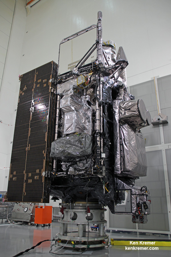 |
| Side view of NASA/NOAA GOES-R next gen weather observation satellite showing solar panels and instruments inside Astrotech Space Operations cleanroom, in Titusville, FL. Credit: Ken Kremer/kenkremer.com/spaceupclose.com |
The Geostationary Operational Environmental Satellite
Program (GOES) system consists of a series of geostationary
weather observation satellites orbiting more than 22,000 miles above Earth developed for the nation as part of a cooperative joint effort between NASA and the National Oceanic and Atmospheric
Administration (NOAA).
Program (GOES) system consists of a series of geostationary
weather observation satellites orbiting more than 22,000 miles above Earth developed for the nation as part of a cooperative joint effort between NASA and the National Oceanic and Atmospheric
Administration (NOAA).
GOES-S is the second in the new
GOES-R series of America’s most powerful and most advanced next generation geostationary weather observation
satellites. It is designed to last for a
15 year orbital lifetime and will deliver a ‘quantum leap’ in weather
forecasting.
GOES-R series of America’s most powerful and most advanced next generation geostationary weather observation
satellites. It is designed to last for a
15 year orbital lifetime and will deliver a ‘quantum leap’ in weather
forecasting.
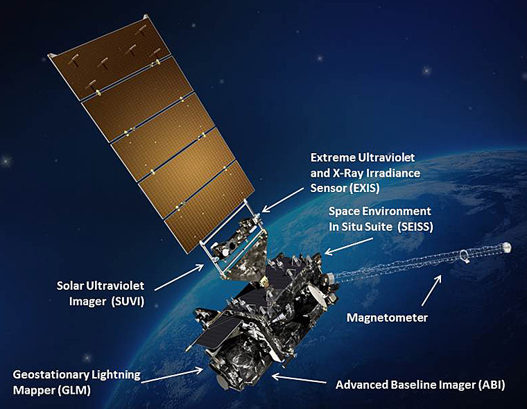
The GOES-R series (including GOES-S)
science suite includes the Advanced Baseline Imager (ABI), Geostationary Lightning Mapper (GLM),
Solar Ultraviolet Imager (SUVI), Extreme Ultraviolet and X-Ray Irradiance
Sensors (EXIS), Space Environment In-Situ Suite (SEISS), and the Magnetometer
(MAG).
science suite includes the Advanced Baseline Imager (ABI), Geostationary Lightning Mapper (GLM),
Solar Ultraviolet Imager (SUVI), Extreme Ultraviolet and X-Ray Irradiance
Sensors (EXIS), Space Environment In-Situ Suite (SEISS), and the Magnetometer
(MAG).
 |
|
GOES-S weather observation satellite
instrument suite graphic. Credit: NASA/NOAA |
How well are the GOES-R/GOES-16 instruments
operating so far in orbit?
operating so far in orbit?
“So far yes the instruments on 16 are meeting or exceeding
expectations. We are very excited,” Walsh told Space UpClose.
expectations. We are very excited,” Walsh told Space UpClose.
“ABI is the primary instrument
that gets most of the imagery and glory along with the GLM. We started ABI
development in 2001. So its truly 2010s technology development.”
that gets most of the imagery and glory along with the GLM. We started ABI
development in 2001. So its truly 2010s technology development.”
“And there are two instruments that always point to the
sun, SUVI and EXIS – that’s for Ultraviolet (UV) and extreme UV regions. These
give us a sense of solar activity so that we can make forecasts in case we get
impacted by solar wind or other solar particle hits.”
sun, SUVI and EXIS – that’s for Ultraviolet (UV) and extreme UV regions. These
give us a sense of solar activity so that we can make forecasts in case we get
impacted by solar wind or other solar particle hits.”
“Two more instruments are the magnetometer and SEIS which
check for impacts on the spacecraft from the sun, and that’s important for its
impact on for example communications, GPS support, spacecraft and astronauts
operation in Earth orbit.”
check for impacts on the spacecraft from the sun, and that’s important for its
impact on for example communications, GPS support, spacecraft and astronauts
operation in Earth orbit.”
“So, we are an Earth pointing and solar pointing mission.”
“The ABI is a really flexible instrument that can look at
different scales. It can look at the full western hemisphere, it can look at
CONUS and it can look at 1000 km x 1000 km mesoscale regions. And those are pretty
important.”
different scales. It can look at the full western hemisphere, it can look at
CONUS and it can look at 1000 km x 1000 km mesoscale regions. And those are pretty
important.”
“We work with the NWS to point at that mesoscale region. And
each satellite has the ability to have two of them which can update every
minute. And if we overlap them we can update every 30 seconds.”
each satellite has the ability to have two of them which can update every
minute. And if we overlap them we can update every 30 seconds.”
It also assists with Tornado detection.
“This is really valuable during the hurricane forecasting
season, for example like we saw last fall.”
season, for example like we saw last fall.”
“Using those mesoscale regions for instance we can look at
tornadic activity in the springtime in the Midwest and focus in and try to
predict what’s going on,” said Walsh
tornadic activity in the springtime in the Midwest and focus in and try to
predict what’s going on,” said Walsh
“The most valuable aspect of the 1 minute imagery is actually
before the storms are formed – because you have an environment that is capable
of producing supercell thunderstorms which can in turn produce tornadoes,”
added Lindsey.
before the storms are formed – because you have an environment that is capable
of producing supercell thunderstorms which can in turn produce tornadoes,”
added Lindsey.
“So with the 1 minute refresh we can actually see individual
cumulous clouds that are trying to form. They get up and get blown over by the shear
and repeat that cycle.”
cumulous clouds that are trying to form. They get up and get blown over by the shear
and repeat that cycle.”
“But eventually you get a storm forming – and that’s known as
convective initiation. And after the storms form into actual supercell storms then
the satellite will be used in concert with the radars we have.”
convective initiation. And after the storms form into actual supercell storms then
the satellite will be used in concert with the radars we have.”
“The radars are still the primary tool for issuing the tornado
warnings. So this may not revolutionize tornado
warning lead times – but it will help tremendously in the prestorm analysis.”
warnings. So this may not revolutionize tornado
warning lead times – but it will help tremendously in the prestorm analysis.”
“So when the storm prediction center issues severe storm watches
and their convective outlooks this will help them in evaluating the environment
before the storms are formed and
deciding exactly where and when to place these watches.”
and their convective outlooks this will help them in evaluating the environment
before the storms are formed and
deciding exactly where and when to place these watches.”
The weather forecast shows a 80 percent
chance of favorable weather conditions for Thursday’s near sunset
blastoff.
chance of favorable weather conditions for Thursday’s near sunset
blastoff.
Watch for Ken’s continuing onsite coverage of NASA, SpaceX,
ULA, Boeing, Lockheed Martin, Orbital ATK and more space and mission
reports direct from the Kennedy Space Center and Cape Canaveral Air Force
Station, Florida.
ULA, Boeing, Lockheed Martin, Orbital ATK and more space and mission
reports direct from the Kennedy Space Center and Cape Canaveral Air Force
Station, Florida.
Stay tuned here for Ken’s continuing
Earth and Planetary science and human spaceflight news: www.kenkremer.com –www.spaceupclose.com –
twitter @ken_kremer – ken
at kenkremer.com
Earth and Planetary science and human spaceflight news: www.kenkremer.com –www.spaceupclose.com –
twitter @ken_kremer – ken
at kenkremer.com
………….
Ken’s upcoming outreach events:
Learn more about the upcoming GOES-S
weather satellite launch, SpaceX Falcon Heavy
and Falcon 9 SES-16/GovSat-1 launches on Jan. 30 & Feb. 6, NASA missions,
ULA Atlas & Delta launches, SpySats and more at Ken’s upcoming outreach
events at Kennedy Space Center Quality Inn, Titusville, FL:
weather satellite launch, SpaceX Falcon Heavy
and Falcon 9 SES-16/GovSat-1 launches on Jan. 30 & Feb. 6, NASA missions,
ULA Atlas & Delta launches, SpySats and more at Ken’s upcoming outreach
events at Kennedy Space Center Quality Inn, Titusville, FL:
Feb 27/28: “GOES-S weather satellite launch,
SpaceX Falcon Heavy & Falcon 9 launches, ULA Atlas USAF SBIRS GEO 4 missile
warning satellite, SpaceX GovSat-1, CRS-14 resupply launches to the ISS, NRO
& USAF Spysats, SLS, Orion, Boeing and SpaceX Commercial crew capsules, ,
OSIRIS-Rex, Juno at Jupiter, InSight Mars lander, Curiosity and Opportunity
explore Mars, NH at Pluto and more,” Kennedy Space Center Quality Inn, Titusville,
FL, evenings. Photos for sale
 |
|
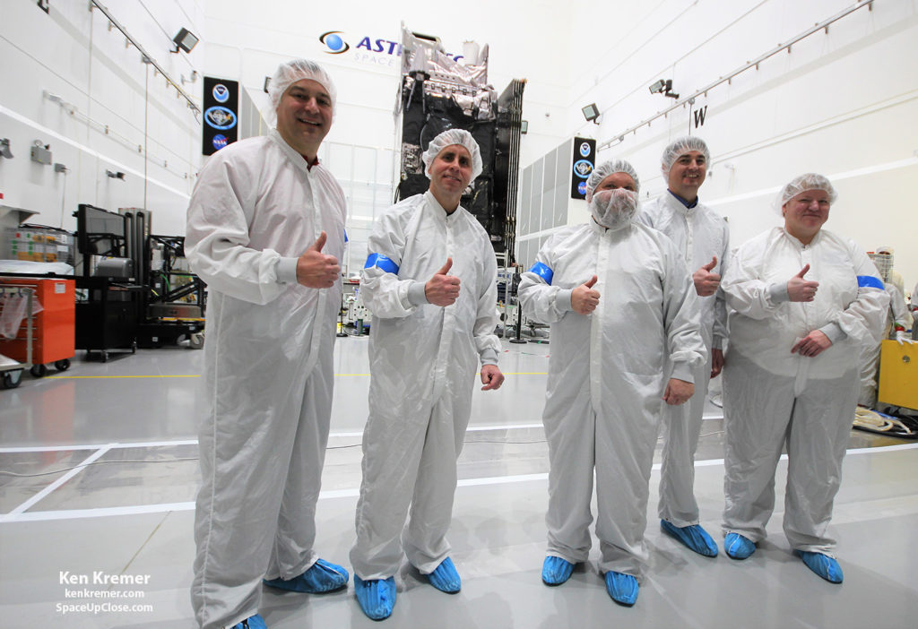
The NASA/NOAA/Lockheed Martin/Harris
GOES-S team gives a big thumbs up for the dramatic leap in capability this next gen weather observation satellite will provide to the Western US – during media briefing at Astrotech Space Operations, in Titusville, FL on Jan. 16, 2018. Ken Kremer/SpaceUpClose.com/kenkremer.com
|