 |
|
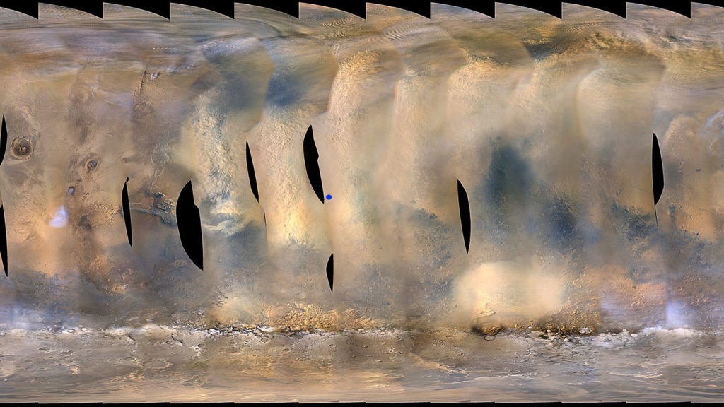
This global map of Mars
shows a growing dust storm as of June 6, 2018. The map was produced by the Mars
Color Imager (MARCI) camera on NASA’s Mars Reconnaissance Orbiter spacecraft.
The blue dot indicates the approximate location of NASA’s Opportunity rover. Credits:
NASA/JPL-Caltech/MSSS
|
Ken Kremer — SpaceUpClose.com — 11 June 2018
CAPE
CANAVERAL, FL – A massive dust storm rapidly
spreading across Mars since early June has forced a halt to science operations by
NASA’s solar powered Opportunity rover – as day has effectively been turned
into night thereby starving the spacecraft of life-giving power.
“Science operations for NASA’s
Opportunity rover have been temporarily suspended as it waits out a growing
dust storm on Mars,” NASA said in a statement.
“A dark, perpetual night has settled
over the rover’s location in Mars’ Perseverance Valley,”
NASA reported on June 10.
 |
|
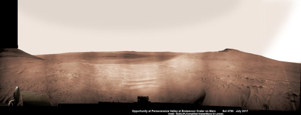
Historic 1st descent down Martian
gully. Panoramic view looking down Perseverance Valley after entry at top was
acquired by NASA’s Opportunity rover scanning from north to south. It shows
numerous wheel tracks at left, center and right as rover conducted walkabout
tour prior to starting historic first decent down a Martian gully – possibly
carved by water – and looks into the interior of Endeavour crater. Perseverance
Valley terminates down near the crater floor in the center of the panorama. The
far rim of Endeavour crater is seen in the distance, beyond the dark floor. Rover
mast shadow at center and deck at left. This navcam camera photo mosaic was
assembled by Ken Kremer and Marco Di Lorenzo from raw images taken on Sol 4780
(5 July 2017) and colorized. Credit: NASA/JPL/Cornell/Ken
Kremer/kenkremer.com/Marco Di Lorenzo
|
The 2018 storm is now far worse
than the prior global dust storm that afflicted Opportunity back in 2007 and is
centered over the rover – and covers about a quarter
of the planet!
“The storm is one of the most
intense ever observed on the Red Planet.”
The long lived robot was launched
in 2003, landed in 2004 and has been making breakthrough science and
exploration discoveries ever since during its utterly remarkable 14.5-year-long overland trek
across the 4th planet from the sun.
“As of June 10, it covered more
than 15.8 million square miles (41 million square kilometers) – about the area
of North America and Russia combined. It has blocked out so much sunlight, it has
effectively turned day into night for Opportunity, which is located near the
center of the storm, inside Mars’ Perseverance Valley.”
See herein our exclusive
Opportunity rover mosaics showing the view from Perseverance Valley and our route
map – created by the imaging team of Ken Kremer and Marco Di Lorenzo
 |
|
NASA’s Opportunity rover acquired
this Martian panoramic view from a promontory that overlooks Perseverance Valley
below – scanning from north to south. It is centered on due East and into the
interior of Endeavour crater. Perseverance Valley descends from the right and
terminates down near the crater floor in the center of the panorama. The far
rim of Endeavour crater is seen in the distance, beyond the dark floor. Rover
deck and wheel tracks at right. This navcam camera photo mosaic was assembled
from raw images taken on Sol 4730 (14 May 2017) and colorized. Credit:
NASA/JPL/Cornell/Ken Kremer/kenkremer.com/Marco Di Lorenzo
|
As a
result of the ever thicker swirling dust, Opportunity’s power levels had dropped significantly thus requiring
the rover to shift to minimal operations with only limited communications every
few days to conserve power.
Power is also needed
to run the heaters that keep the vital electronic boxes warm and protect them
from deadly sub-freezing temperatures.
Opportunity’s twin
sister rover Spirit died in 2011 when the robots solar panels produced
insufficient power to the electronics box heaters because it was stuck in a
sand trap.
“Engineers will
monitor the rover’s power levels closely in the week to come. The rover needs
to balance low levels of charge in its battery with sub-freezing
temperatures. Its heaters are vitally important to keeping it alive, but
also draw more power from the battery.”
The giant dust storm began June 1 and has been growing even
since in intensity and area.
By June 6 it had ballooned to more than 7 million square miles (18
million square kilometers).
The dust storm was first detected by the Mars Reconnaissance Orbiter (MRO) – another NASA spacecraft currently orbiting the
Red Planet and which relays a portion of
the science data back to scientists on Earth.
An impressive global map of Mars showing the growing dust storm – see lead image above – was
taken on June 6, 2018 by the Mars Color Imager (MARCI) camera onboard the MRO spacecraft.
The approximate location of NASA’s Opportunity rover at Endeavour
Crater is marked by a blue dot.
 |
|
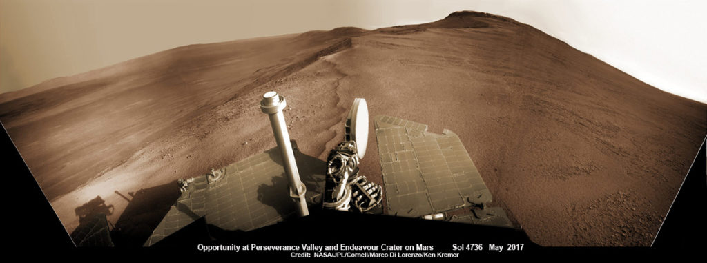
Opportunity rover looks south
from the top of Perseverance Valley along the rim of Endeavour Crater on Mars
in this partial self portrait including the rover deck and solar panels.
Perseverance Valley descends from the right and terminates down near the crater
floor. This navcam camera photo mosaic was assembled from raw images taken on
Sol 4736 (20 May 2017) and colorized. Credit: NASA/JPL/Cornell/Marco Di
Lorenzo/Ken Kremer/kenkremer.com
|
Opportunity is currently descending down and exploring Perseverance Valley located along the eroded western rim of
the gigantic 22-km diameter impact crater named Endeavour.
Although Opportunity was only warrantied
for “90 Sols” of operation, it is now enjoying its 15th year of
continuous operations of the frigid alien world.
“Perseverance Valley” is an
ancient fluid-carved valley “possibly water-cut” that could hold groundbreaking
clues to the potential origin and evolution of life on Mars – if it ever
existed.
As of today, June 11, 2018,
long lived Opportunity has survived over 5112 Sols (or Martian days) roving the
harsh environment of the Red Planet.
Opportunity has
taken over 228,771 images and traversed over 28.06 miles (45.16 kilometers) – more than a marathon.
Watch for Ken’s continuing onsite coverage of NASA, SpaceX, ULA,
Boeing, Lockheed Martin, Orbital ATK and more space and mission reports direct
from the Kennedy Space Center, Cape Canaveral Air Force Station, Florida and
Wallops Flight Facility, Virginia.
Stay tuned here for Ken’s continuing Earth and Planetary science and human
spaceflight news: www.kenkremer.com
–www.spaceupclose.com – twitter @ken_kremer – email: ken at kenkremer.com
 |
|
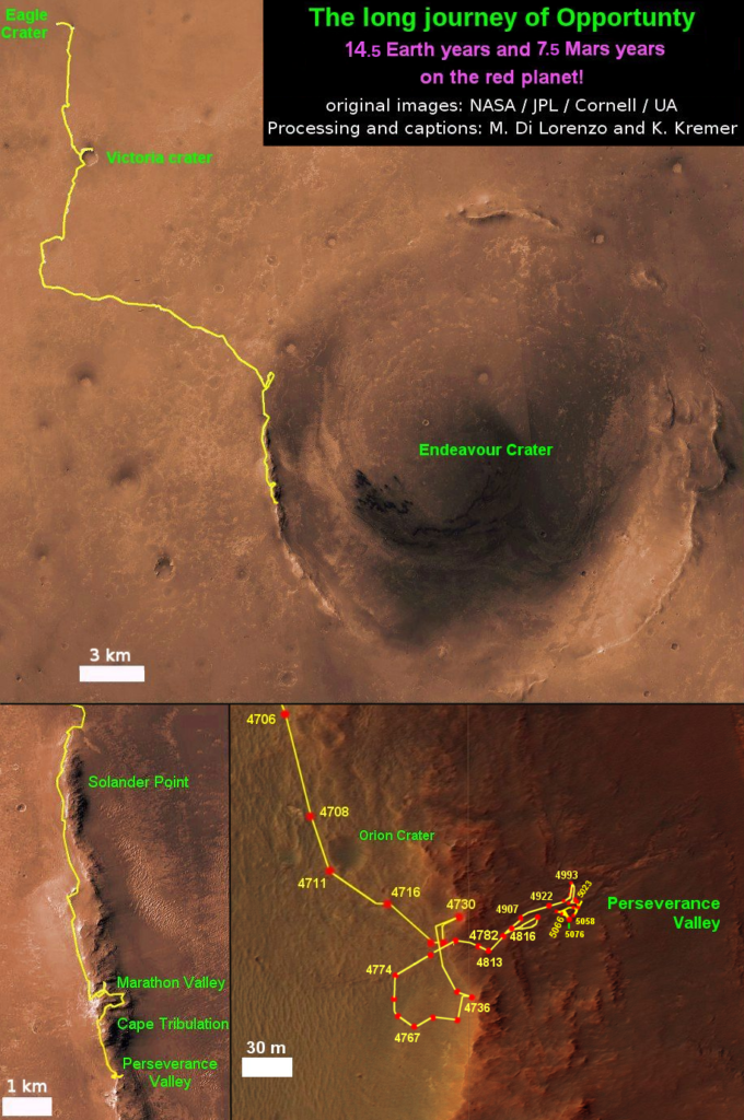
14 Year Traverse Map for NASA’s Opportunity rover from 2004 to
2018. This map shows the entire 45 kilometer (28 mi) path the rover has driven
on the Red Planet during over during
over 14.5 Earth-years (7.5 Mars-years) and
more than a marathon runners
distance for over 5115 Sols, or Martian days, since landing inside Eagle Crater
on Jan 24, 2004 – to current location at Perseverance Valley at the western rim
of Endeavour Crater. The rover reached Perseverance Valley in May 2017 and descended
about halfway by June 2018. Its likely a
water carved Martian gully. Opportunity surpassed Marathon distance on Sol 3968
after reaching 11th Martian anniversary on Sol 3911. Opportunity discovered
clay minerals at Esperance – indicative of a habitable zone – and searched for
more at Marathon Valley. Credit: NASA/JPL/Cornell/ASU/Marco Di Lorenzo/Ken
Kremer/kenkremer.com
|


